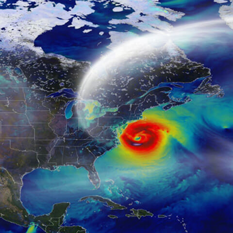
As the 2020 hurricane season begins, a new study published today by The Nature Conservancy and Arizona State University’s Center for Biodiversity Outcomes shows that Federal Emergency Management Agency, or FEMA, flood hazard maps underpredicted the extent of recent hurricane-induced floods, their effect on vulnerable human communities and consequential environmental damage in the North Carolina region.
This study, titled “Repeated Hurricanes Reveal Risks and Opportunities for Social-Ecological Resilience to Flooding and Water Quality Problems” was published in Environmental Science and Technology.
This research was spearheaded by ASU Center for Biodiversity Outcomes postdoctoral research associate and TNC NatureNet Science Fellow Danica Schaffer-Smith, along with ASU affiliated faculty members Soe W. Myint and Daoqin Tong from the School of Geographical Sciences and Urban Planning, Rebecca L. Muenich from the School of Sustainable Engineering and the Built Environment, Ira A. Fulton Schools of Engineering and TNC Water Program Director (North Carolina Chapter) Julie E. DeMeester.
The research team used satellite images to map flooding from Hurricane Matthew in 2016 and Hurricane Florence in 2018. The data collected revealed the actual extent of flooding, helping more accurately assess impacts beyond data previously collected by government agencies.
The ASU and TNC research team’s investigation revealed that flooding happened past the established legal guidelines. It also revealed how city water quality was impoverished after hurricane flooding due to compromised wastewater treatment plants, affecting certain communities that were disproportionally at risk.
“Our research showed that widespread flooding occurred well outside of the boundaries established by the legal definitions of floodplains,” said Shaffer-Smith. “Florence and Matthew impacted a footprint more than 23 percent greater than the 100-year floodplain, well beyond what current flood hazard maps predicted. We need better maps to better protect our communities.”
This study provides the first assessment of the two storms’ potential impact on water quality in the region. In total, 118 municipal water intakes and 206 public water supply wells lie in the repeatedly flooded areas. Another 40 hazardous waste sites, 339 industrial wastewater facilities and 218 municipal wastewater treatment plants were likely compromised by the storms.
Collecting data via satellite radars expedites assessments because the radars can pass through threes and avoid the potentially hazardous conditions of collecting data manually.
These findings could improve community planning for greater resiliency during future storms. In addition to helping reduce the impact on water quality, they can also guide future nature restoration plans in the region.
To learn more, access TNC’s press release.